
Jingyu supports the integration of data resources from existing information systems of emergency management departments, deeply integrates cutting-edge technologies such as 5G, big data, cloud computing, AI, and converged communications, organically combines information, technology, equipment with emergency management business needs, covering multiple business areas including urban safety monitoring, production safety monitoring, natural disaster monitoring, and emergency response. It empowers user business applications and achieves "intelligent perception, intelligent dispatch, intelligent disposal, intelligent assessment, and intelligent improvement", effectively improving cross-departmental decision-making and resource coordination efficiency.
In today's society, with the acceleration of urbanization and the rapid development of technology, emergency management faces unprecedented challenges. Various unexpected events, such as natural disasters and production accidents, occur frequently, posing a serious threat to urban safety and social stability. Traditional emergency management methods can no longer meet the complex and changing management needs of modern times. Therefore, there is an urgent need to improve the efficiency and response speed of emergency management through informatization and intelligence.
Furthermore, with the maturity of cutting-edge technologies such as 5G, big data, cloud computing, and AI, strong support has been provided for technological innovation in the field of emergency management. These technologies can help emergency management departments better integrate data resources from existing information systems, improving the scientific nature of decision-making and the efficiency of resource coordination.
This proposal aims to fully enhance the intelligence level of emergency management by integrating existing information system data resources of emergency management departments and deeply integrating cutting-edge technologies such as 5G, big data, cloud computing, AI, and converged communications. The specific objectives are as follows:
Realize intelligent perception and decision-making: Through the integration of multi-source data, achieve comprehensive intelligent perception in areas such as urban safety, production safety, and natural disasters, providing data support for fast and accurate decision-making.
Improve resource coordination efficiency: Optimize resource allocation through big data analysis and cloud computing technology, enhancing collaboration and resource coordination efficiency across departments.
Build a comprehensive emergency management system: Improve the emergency management system and enhance its systematic and scientific nature through emergency management big data governance and the establishment of an emergency knowledge base.
Empower user business applications: Enable users to more efficiently conduct safety monitoring, early warning, and emergency response through technical support, thereby improving overall emergency management capabilities and response speed.
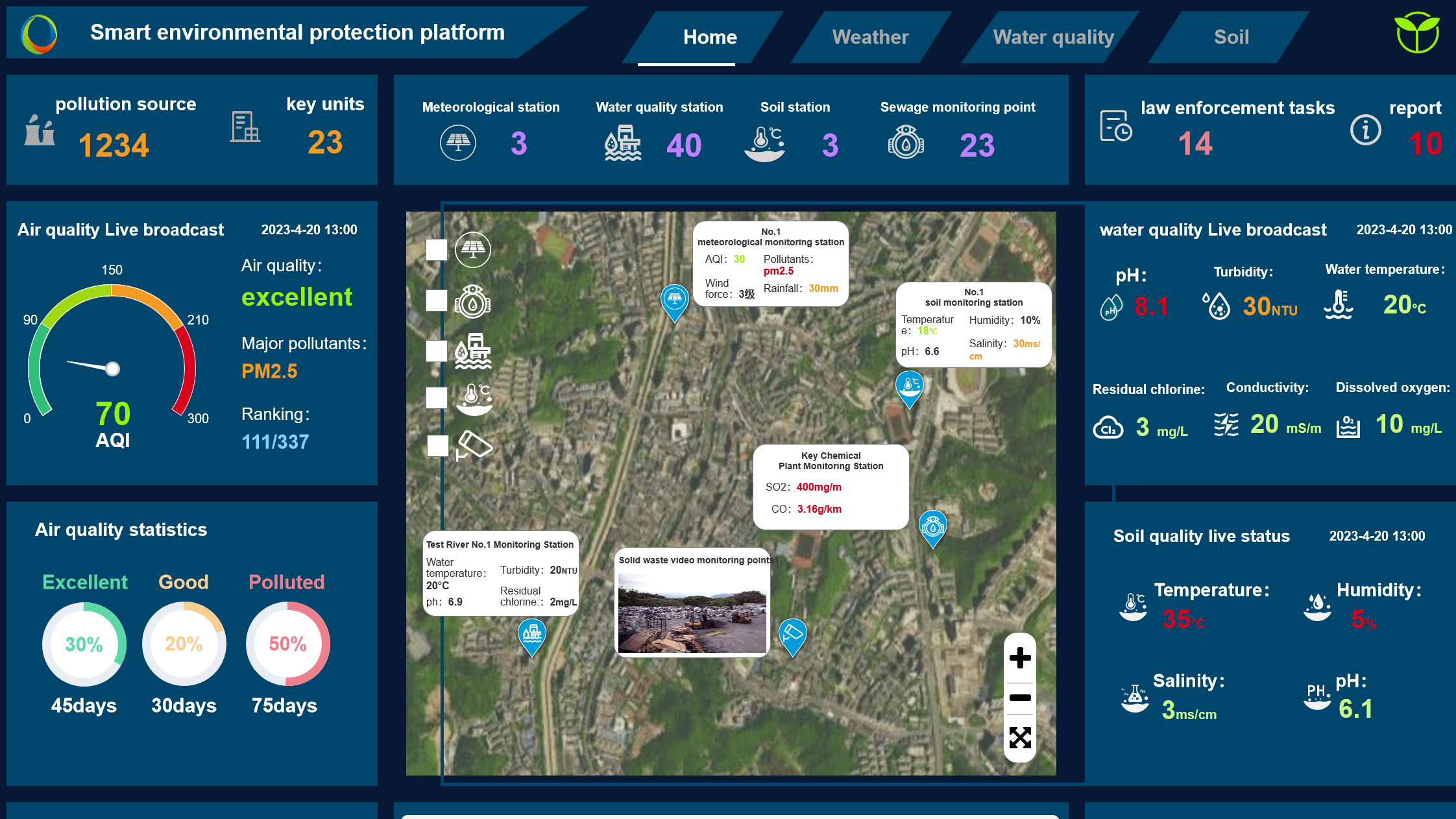
Supports the integration of information resources from various fields of emergency management, detailed display of information on elements such as jurisdictional streets, buildings, and infrastructure, comprehensive monitoring of enterprises, personnel, vehicles, key projects, hazardous sources, emergency events, emergency resources, etc., assisting emergency departments to comprehensively control the security situation of large areas.
Supports comprehensive monitoring and early warning alerts for various supervised enterprises such as coal mines, non-coal mines, and hazardous chemicals within the jurisdiction. Supports the establishment of enterprise portraits, and can combine professional calculation models to conduct multi-dimensional analysis of key indicators such as the impact area and impact intensity of major hazardous sources, improving the effectiveness of emergency command departments in safety production management of enterprises.
Following the idea of "separation of data and application, intelligent drive", an emergency management big data governance system is constructed to achieve full life cycle management of data access, processing, storage, and application, and build a "vertical to the end, horizontal to the edge" data business flow model, providing strong support for emergency management business.
Supports real-time monitoring and early warning alerts for the operational status of management elements such as large urban buildings, large public facilities, underground pipelines, integrated pipe galleries, and rail transit; provides geospatial overlay analysis for scientific analysis of key indicators such as coupling risk, operational safety pressure, and social security coverage, effectively improving the effectiveness of managers' supervision of urban safety.
Supports the integration of data from various natural disaster supervision departments, real-time monitoring and early warning alerts for the development trend of various natural disasters such as meteorological disasters, forest and grassland fire hazards, earthquake disasters, geological disasters, floods and droughts; supports the construction of event maps for post-analysis of disaster evolution processes and impact ranges.
Supports intelligent graded early warning of abnormal events, real-time alerts, rapid positioning and identification of alert content. At the same time, it can link cross-departmental resources for collaborative consultation, intelligently perform automatic event distribution, one-click direct call, collaborative scheduling of multiple police forces, materials, facilities and other linkage resources, real-time tracking and monitoring of the entire event handling process, intelligent quantitative evaluation of event handling effects, significantly improving event handling efficiency and refined management level.