The three-dimensional regional prevention and control solution deeply integrates IoT, big data, video surveillance, artificial intelligence, public security checkpoints, and other technical applications, effectively integrates various social information resources, and supports monitoring and management from multiple dimensions such as police force and alarm distribution, video surveillance, checkpoint distribution, district population, and key places. It supports police monitoring, situation analysis, and emergency command and dispatch under emergencies, realizes visualization of normal management and abnormal event handling, and effectively improves the social security prevention and control capabilities of the public security department.
With the rapid economic and social development of the country and the enhancement of its international status, the safety and prevention work in various crowded areas of urban public spaces has become increasingly important. For areas such as government buildings, schools, hospitals, tourist attractions, commercial districts, and key urban locations, we need to build a comprehensive, efficient, and intelligent three-dimensional regional prevention and control system to ensure public safety.
This solution aims to achieve comprehensive, multi-level, and dynamic management and control of "people, places, events, things, and organizations" by integrating existing information systems, establishing a new public security management information system, and relying on technologies such as the Internet of Things, big data, cloud computing, and artificial intelligence. The goal is to provide adequate early warning before incidents, rapid response during incidents, and proper recovery after incidents, comprehensively improving the level of public safety management.
Based on the Geographic Information System, it can present detailed information such as city streets, landmarks, buildings, moving targets, and video data. It provides comprehensive and all-weather monitoring of key areas within the jurisdiction. Visual monitoring is carried out on security elements such as the surrounding environment of key locations, activities of key personnel, trajectories of key vehicles, and data analysis and early warning information. Automatic alarms, trajectory tracking, and video association display are realized, providing comprehensive monitoring of "people, vehicles, locations, events, and objects" within the jurisdiction and supporting decision-making.
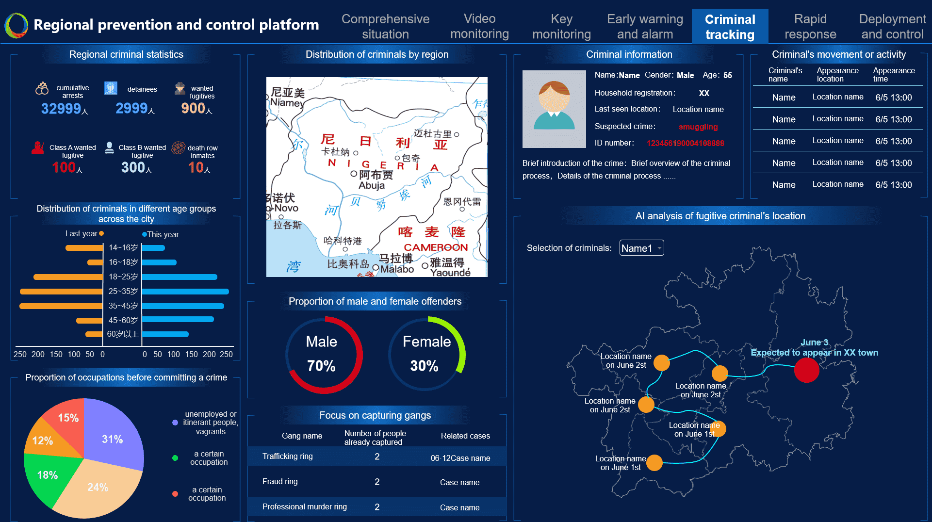
Supports monitoring of key personnel similar to public security and sensitive groups, including information such as the number of key personnel, sensitive events, flow direction, geographical distribution, movement trajectory, and inflow and outflow methods, achieving "knowing where they are going and tracking their movements," and enhancing the ability of public security departments to proactively prevent and combat crime.
Supports real-time monitoring of the deployment of police forces, vehicles, materials, and linked resources within the jurisdiction, as well as traffic flow, pedestrian flow, and other situations. It also supports visualization of the scope of support, support routes, and support processes, effectively improving the efficiency of safety guarantees for major events and enhancing the ability and level of command personnel to handle emergencies.
Supports integration with mainstream public opinion information collection systems, real-time monitoring and analysis of sensitive information from various media channels, and supports analysis of public opinion development trends, traceability analysis of public opinion events, and analysis of dissemination paths, improving managers' monitoring and response efficiency to online public opinion.
Supports three-dimensional display of the surrounding environment, architectural appearance, and internal detailed structure of key sites; it can also integrate system data such as video surveillance, perimeter alarms, and mobile law enforcement terminals to monitor key site locations, personnel, vehicles, alarm events, and other elements, assisting users in accurately and effectively controlling micro-security situations.
Supports integrating real-time image information collected by various public security checkpoints to automatically alert and track the trajectories of key vehicles, and display associated video surveillance footage and detailed information about the vehicle (such as direction of arrival, direction of departure, vehicle type, incident type, etc.), improving the effectiveness of vehicle inspection and control.
Supports accessing real-time traffic condition data to monitor information such as congested road segments, traffic incidents, and surveillance videos within the jurisdiction. Combined with professional model algorithms, it scientifically evaluates the traffic situation in the jurisdiction to provide decision support for traffic management and command.
Supports integrating real-time data collected by business systems such as checkpoints, electronic police, and mobile inspections, monitoring and analyzing information such as the real-time location, movement trajectory, and vehicle and driver files of key monitored vehicles, providing strong support for vehicle prevention and control during event security.