
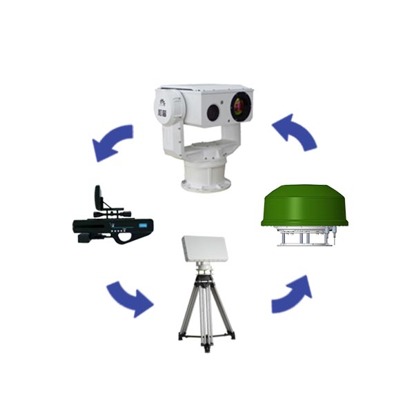
The "Guard III" anti-UAV defense system consists of a radio detection and positioning subsystem, a radio direction finding detection subsystem, a radar detection subsystem, an optoelectronic tracking subsystem, a navigation inducement subsystem, a radio interference countermeasure subsystem and a portable ( Hand-held) radio interference countermeasure subsystem and other equipment and RGS1000 low-altitude early warning and control platform are jointly composed.
Follow Us:
radio detection subsystem
1) Passive radar, no radiation, hidden work, long-term use will not cause any adverse effects on the human body;
2) It can monitor and track UAV and flight control signals at the same time, and the detection speed is fast, which is convenient for early warning and disposal;
3) 360° omnidirectional coverage, which can capture UAV image transmission and remote control flight control signals hidden between buildings and trees.
radar detection subsystem
1) The ability to monitor low-altitude, slow and small targets, flexible deployment, fully automatic, and all-weather work;
2) The three-coordinate primary radar has altimetry capability;
3) Support unattended operation, reduce the difficulty of work, and avoid the interference of electromagnetic radiation to operators.
Photoelectric tracking subsystem
1) It can carry a long-focus visible light camera, a large-diameter infrared thermal imager, and optional sensing modules such as laser illuminator, laser ranging, positioning and navigation, digital compass, etc., to achieve ultra-long-distance target observation;
2) It can integrate high-definition visible light, cooled/uncooled thermal imaging, and laser illuminators. The advantages of multi-band detection are complementary, the combination of active and passive detection, and multi-source data aggregation and fusion processing. monitoring needs;
3) The automatic tracking module designed with a variety of advanced target acquisition algorithms and tracking algorithms, supplemented by high-precision servo control, ensures stable tracking of the target during fast flight and direction change.
Navigational inducement subsystem
1) GPS/GLONASS/BDS/Galileo and other satellite navigation civil frequency bands, covering a wide range;
2) It can drive the target UAV away in the designated direction, induce the UAV to the designated area and make it make a forced landing;
3) Send repressive navigation interference signals so that the UAV cannot receive navigation and positioning signals to achieve defense purposes.
Radio Interference Countermeasure Subsystem
1) It has the ability to effectively interfere with the signals of general-purpose UAVs and model-modified UAVs, causing them to return or make forced landings;
2) The frequency range of navigation signal processing includes: GPS, GLONASS, Beidou, Galileo and other navigation systems;
3) The working mode of data link processing and navigation signal processing can be freely selected or set by the user.
It is mainly used for low-altitude security protection in key places such as airports, prisons, nuclear, biological and chemical industries, conference centers, office buildings, oil fields, and oil depots.
Model name | Guard III anti-uav defense system |
Radio detection subsystem | 1. Operating distance: ≥5 km 2. Frequency: 0.3-6 ghz 3. Direction finding accuracy: 3 ° (RMS) 4. Coverage: 360 ° 5. Covering pitch: 0 ° ~ 70 ° 6. Height Coverage: 0-1000m 7. Detection Object: remote control signal, image transmission signal 8. Communication Interface: Ethernet (RJ45) 9. Power supply: AC220V 10. Power consumption: ≤100W 11. Size: ≤1358 * 1358 * 541(mm) 12. Weight: 30Kg |
Radar Detection Subsystem | 1. Action distance: ≥5 km (DJI Sprite 4) 2. Radar Band: Ku 3. Technical system: LINEAR frequency modulation pulse 4. Scanning mode: Azimuth Scanning + pitch frequency scanning 5. Pitch range: 0 ° ~ 40 ° 6. Distance accuracy: ≤10m 7. Azimuth accuracy: ≤0.6 ° 8. Pitch accuracy: ≤0.6 ° 9. Data rate: 6s 10. Target capacity: ≥200 batches 11. Power supply: AC220V 12. Power consumption: ≤160W 13. Size: ≤610 × 270 × 440(mm) 14. Weight: 26Kg |
Photoelectric tracking subsystem | 1. Operating distance: visible light ≥3 km, infrared ≥3 km 2. Infrared Detector: refrigerated mercury cadmium telluride (MCT) infrared focal plane 3. The spectral range is from 3.7 μm to 4.8 μm 4. Resolution: 640 × 512 5. NETD: better than 20MK 6. Lens focal length: 22-450mm continuous zoom lens 7. Infrared sensor: 1/1.8′ star-level CMOS, ICR color black 8. Resolution: 1920 × 1080 9. Focal length: 12-860mm, HD electric zoom lens 10. FOG transmission: optical/electronic dual fog transmission is supported 11. Tracking mode: manual, automatic tracking, support radar linkage 12. Tracking function: built-in multiple tracking algorithms, support multi-target detection, automatic capture, temporary occlusion and so on 13. Windows: double/triple windows, 2/3 band sensors can be carried at the same time 14. Horizontal range: N × 360 ° continuous rotation, after power failure can be mechanically locked 15. Pitch Range: -90 ° ~ + 90 ° , with soft limit function, program can be set 16. Rotation Speed: horizontal 0.01 ° ~ 80 °/s, pitch 0.01 ° ~ 60 °/s 17. Power supply: AC220V 18. Power consumption: ≤500W 19. Size: ≤572mm × 472mm × 655mm 20. Total weight: ≤90kg |
Navigation seduction subsystem | 1. Spoofing frequency: GPS/GLONASS/BDS (standard) , expandable to up to 7 frequencies 2. Range: 60 km (decoy)/30 km (jamming) 3. Onset time: ≤3 seconds 4. Accuracy of fixed-point guidance: Error ≤50m (continuous guidance is required) 5. Course control accuracy: < 0.5 ° (with high radar data) 6. Fixed-point control mode: automatic 7. Coverage Azimuth: 0 ° ~ 360 ° (by SERVO + directional antenna to achieve + automatic north-seeking) 8. Coverage pitch: -15 ° ~ 60 ° (via SERVO + directional antenna + automatic north seeking) 9. Power supply: AC220V 10. Power consumption: ≤200W 11. Size: ≤380 * 250 * 120(mm) 12. Weight: 20Kg |
Fixed radio interference counter subsystem | 1. Operating distance: ≥0.5 km (0.4 ghz, 0.9 ghz) , ≥1.5 km (2.4 ghz, 5.8 ghz, 1.5 ghz) 2. Operating bands: 420-440MHz, 840-940MHz, 1570-1670MHz, 2400-2500MHz, 5700-5900MHz 3. Modulation type: sweep frequency 4. Beam coverage: horizontal ≥60 ° * vertical ≥45 ° 5. 360 ° * vertical ≥0 ° ~ 90 ° 6. Module Power: 0.4 GHZ20W, 0.9 ghz20w, 1.5 ghz10w, 2.4 ghz20w, 5.8 ghz5w 7. The rotating speed of the head is 0.01 ° ~ 12 °/s 8. Equipment Linkage: radar detection/spectrum detection/photoelectric detection + orientation (head-RRB- 9. Power supply: AC220V 10. Power consumption: ≤300W 11. Size: ≤651 * 286 * 330(mm) 12. Weight: 20Kg |
Portable radio interference suppression subsystem | 1. Operating distance: ≥1.5 km 2. Operating Band: 0.4 ghz, 0.9 ghz, 1.5 ghz, 2.4 ghz, 5.8 ghz 3. Output Power: 0.4 ghz 20W, 0.9 ghz 20W, 1.5 ghz 10W, 2.4 ghz 20W, 5.8 ghz 5W 4. Antenna gain: 0.4 ghz 5DB, 0.9 ghz 7db, 1.5 ghz 12DB, 2.4 ghz 10DB, 5.8 ghz 10DB 5. Battery capacity: 7200mAh 6. Fuselage size: 685mm * 230mm * 80mm (mm) 7. Weight: 4.8 kg |
RGS1000 low altitude early warning control platform | 1. Integrated Management and display: platform integrated design, centralized management and control, centralized display, more efficient operation 2. Distributed: support distributed deployment, Device Control Service, service scheduling service distributed deployment, support by region deployment, support multi-client simultaneous use, support distributed streaming server technology 3. Deployment Display: displays deployment information for detection and interception equipment 4. Multi-screen display: support video preview, electronic map, video monitoring, video playback and information management split-screen display, support multiple video preview interface split-screen display 5. Log information: support query run log, alarm log, Operation Log and other information, support by organization, equipment, time and other conditions query log information 6. System settings support setting map address, support setting local storage path, support personal password modification, support connection mode settings, support automatic variable parameter settings, support target linkage parameter settings |